Deleted
Deleted Member
Posts: 0
|
Post by Deleted on Mar 5, 2009 11:55:06 GMT
Thought I'd start a new thread for this otherwise it gets mixed up with the Watchet trip. Ok, Ok, I wasn't going to mention it ;D - yes that was us that Allen heard talking to Swansea Coastguard whilst 'unintentionally stationary' on the edge of Stert Sands. Apparently someone had spotted us and told them. We didn't get it quite right  and just clipped the sandbank at the entrance to the channel. It was pretty much low water so we ended up waiting an hour before getting off. The rudder took a bit of a pounding  = hope its alright. Anyway we managed to get in and had a quiet and sheltered, if very cold night. I've got all the waypoints for the channel and where we actually anchored - but they're on the boat. I'll get them at the weekend and post them here. Cheers, Peter and Elaine |
|
ishtar
Member of CYC  Ishtar
The original Ishtar
Ishtar
The original Ishtar
Posts: 970
|
Post by ishtar on Mar 5, 2009 11:59:50 GMT
That would be great, thanks.
|
|
|
|
Post by allan on Mar 5, 2009 20:33:45 GMT
I must admit that I thought your call to the coastguard sounded amusing. I was impressed with your use of the word "anchored!".
Some years ago I read an article which quoted the commodore of the Burnham on sea yacht club. When asked the best way to navigate into Burnham he said, "Down the M5 and turn right!" He also said the sand can move in one tide, so the route you took on your way out, may not be suitable for your return.
Allan
|
|
Deleted
Deleted Member
Posts: 0
|
Post by Deleted on Mar 7, 2009 16:56:07 GMT
Directions to Burnham: Waypoints (taken from 'Bristol Channel and Severn Cruising Guide') 1. 51 o15'.16N 003 o05'.47W 2. 51 o15'.15N 003 o02'.01W 3. 51 o14'.83N 003 o00'.83W 4. 51 o14'.49N 003 o00'.37W 5. 51 o14'.07N 003 o00'.29W We found this to be predominantly very accurate, but we did come across a sudden shallow patch just before Waypoint 3 - depth suddenly decreased by about 1.7m! I suspect the channel is deeper slightly to port here. It is the point where the channel bears round to starboard and hence we were probably cutting the curve a little fine. Other than that we stuck exactly to this route and from the look of things that IS necessary! We did this route 2hrs after LW springs and other than the shallow patch by waypoint 3, we had about 3.5m depth for most of the way. Be warned - Waypoint 1 is up the channel a bit. Don't come towards it from the NW as we did or you may get the same concerned call from the coastguard that we did! I would recommend coming from due West for about a mile. All the same there is some sort of bar at the entrance which is almost dry at LW springs (0.2m on what I think is our most accurate chart) Once in we anchored just of the river Brue entrance at 51 o15'.61N 003 o00'.58W. This gave us a maximum depth of 8.2m at the top of the tide. We only had about 24m of anchor rode out (which is all we've got), so a bit on the minimal side, but we stayed put all night settling into soft mud for about an hour at low tide. It would be easy to get a bit closer in to Stert Island if you wanted less depth under you at HW. We didn't visit the club pontoon and in fact couldn't see the way in even at mid tide - thats next times challenge. Overall this seems like a good sheltered spot for a quiet night at anchor  , though it would certainly be easier on neaps and I wouldn't like to approach the bar in much of swell either. There are also very few landmarks here, so I would say GPS is essential. There is an alternative route using transits when you've got more water (its in the pilot book - let me know if anyone wants details) Hope all this has been helpful. Cheers, Peter and Elaine (on Sandpiper) |
|
ishtar
Member of CYC
Ishtar
The original Ishtar
Posts: 970
|
Post by ishtar on Mar 8, 2009 8:10:10 GMT
That's great, thanks, Peter. I'll plot these on the chart later and have a look. Off to the boat Jumble, now.
|
|
Deleted
Deleted Member
Posts: 0
|
Post by Deleted on Mar 8, 2009 10:58:26 GMT
Glad to see you're back - was a bit worried about where you might have got to in this weather! - will hopefully be at the club Wednesday night to finally say hello..
|
|
ishtar
Member of CYC
Ishtar
The original Ishtar
Posts: 970
|
Post by ishtar on Mar 8, 2009 13:40:26 GMT
We left yesterday morning with a mind to sail around the Holms. The forecast wind never really arrived, and with just 6 knots, the tide swept us upstream. I thought when the drizzle arrived that the wind would pick up, but it didn't and was just plain miserable, so we sailed up around the North Cardiff buoy and locked in around 15:15 for a couple in the bar.
Vince from Alana was with us - he thinks he may have already met you?
Not sure about Weds, I have a funeral to attend in Derby, so it may be late when I get back, but I'm hoping to make it.
M.
|
|
ishtar
Member of CYC
Ishtar
The original Ishtar
Posts: 970
|
Post by ishtar on Mar 8, 2009 19:02:05 GMT
I've tried to plot this on my chart software, and it looks very close indeed, Peter. It's tricky to plot with a mouse to 3 decimal places, but it does show the track quite well I think. 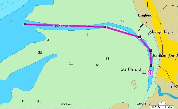 |
|
ishtar
Member of CYC
Ishtar
The original Ishtar
Posts: 970
|
Post by ishtar on Mar 8, 2009 19:08:06 GMT
I've just noticed your anchor point. You say 51 15 .61N? Should that be 51 13.61?
|
|
Deleted
Deleted Member
Posts: 0
|
Post by Deleted on Mar 8, 2009 20:17:57 GMT
Yes, well spotted - our anchor position should read: 51o13'.61N 003o00'.58W
What chart software are you using? Do you get automatic updates? - what was the last one dated?
Cheers,
Peter
|
|
ishtar
Member of CYC
Ishtar
The original Ishtar
Posts: 970
|
Post by ishtar on Mar 8, 2009 20:53:34 GMT
Great, thanks.
The software I use is Garmin Bluechart. I have it on my chartplotter sounder on the boat and on my PC for planning. I like it, but is is very expensive once you start getting into other areas. I paid over £100 for the West Britain chart and that much again when we took the RIB to Scotland diving and I needed a new chart.
I've PM'd you.
|
|
 and just clipped the sandbank at the entrance to the channel. It was pretty much low water so we ended up waiting an hour before getting off. The rudder took a bit of a pounding
  = hope its alright.


 , though it would certainly be easier on neaps and I wouldn't like to approach the bar in much of swell either. There are also very few landmarks here, so I would say GPS is essential. There is an alternative route using transits when you've got more water (its in the pilot book - let me know if anyone wants details)